Projects | Expert-based data analysis and quality processes
-
port_AI – A fully digital twin for port structures using IoT, 5G, BIM, AR and AI methods to establish smart building lifecycle managementThe requirements for the safety and reliability of infrastructure management of infrastructure in the area of sea and inland ports are constantly increasing due to the growing globalisation of trade. The creation of a smart infrastructure should solve various challenges in the management of existing port infrastructure in this project. Digitisation and the use of AI processes are also included in this project under the term smart infrastructure. Only a thoroughly digital management of port infrastructure enables the economical use of resources, forward-looking maintenance, and early and comprehensive damage detection and assessment. This can lead to significant cost savings.Led by: Ingo Neumann, Hamza Alkhatib, Mohammad OmidalizarandiTeam:Year: 2021Funding: Funding programme for innovative port technologies (IHATEC) supported by the Federal Ministry of Transport and Digital Infrastructure (BMVI)Duration: 12/2021 – 02/2025
![]()
![]()
-
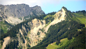
Measurement system analysis and model-based sensor fusion for hydrographic water exchange zone monitoring using unmanned carrier systemsThe aim of the project "Measurement system analysis and model-based sensor fusion for hydrographic water exchange zone monitoring with unmanned carrier systems (WaMUT)", which the GIH is working on on behalf of and in cooperation with the Bundesanstalt für Gewässerkunde (BfG), is the continuous, quality-assured acquisition and modelling of geo-base data of the water exchange zones and shallow water areas of federal waterways to improve the quality of - in particular small-scale - digital terrain models of the watercourse. In contrast to the classic geodetic observation methods for recording bathymetry and topography, the use of unmanned sensor platforms - primarily on land (unmanned aerial vehicle UAV), but also on the water (unmanned surface vessel USV) - has come into focus in recent years. As part of the WaMUT project, these measurement systems are to be validated and, based on this, a quality-assured, integrated measurement programme is to be created in order to be able to record reliable geobase data in the water exchange zones.Led by: Ingo Neumann, Hamza AlkhatibTeam:Year: 2020Duration: 09/2020 - 08/2024
![]()
![]() © BfG
© BfG
-
Risk Minimization in Structural Safty MonitoringOne main goal of structural safety monitoring is minimizing the risk of un-expected collapses of artificial objects and geologic hazards. Behind these activities in the DFG founded project, it is the need of the society in mini-mizing the negative environmental impacts. An optimal configuration for measurement setups and all other decisions shall therefore review and ra-te the risks of an individual monitoring project. Nowadays, the methodolo-gy in many engineering disciplines and mathematically founded decisions are usually based on probabilities and significance levels but not on the risk (consequences or costs) itself.Led by: Ingo NeumannTeam:Year: 2010Funding: DFGDuration: 09/2011 - 08/2014
![]()
![]()
-
Simulation-based optimization of tachymetric network measurementsIn geodetic networks of large extent or with a large number of points, the tachymetric network measurement is usually associated with a high logistical effort. The individual measuring points must be visited again and again in order to align the reflectors to the current tachymeter position. The efficient planning of the measurement has the goal of causing the lowest possible costs or it aims at the shortest possible measuring duration.Team:Year: 2010Duration: 2010 - 2019
![]()
![]()
-
Efficiency optimization of geodetic measurement processesThe efficiency optimization of measurement and evaluation processes of engineering geodesy requires a detailed modeling of the individual sub-steps. This modeling is realized by means of Petri nets. Thus computer-aided simulations can be carried out. To minimize the cost or duration of the measurement processes Genetic algorithms are used as an optimization method.Led by: Hansjörg KuttererTeam:Year: 2009Funding: DFGDuration: 05/2009 - 06/2014
![]()
![]()