
Optimal quality related viewpoint planning of terrestrial laser scanning
 © gih
© gih
| Led by: | Jan Hartmann, Mohammad Omidalizarandi |
| Team: | Jalil Ahmed Baloch |
| Year: | 2023 |
| Date: | 14-02-23 |
| Duration: | 06/2023 – 12/2023 |
| Is Finished: | yes |
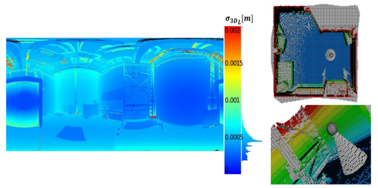
The quality of terrestrial laser scanning (TLS) measurements is influenced by a number of factors. In particular, the scan geometry affects the TLS distance measurement. Besides, the quality of the TLS point clouds is influenced at different incidence angles. Moreover, the spot size and resolution of the TLS measurements are highly correlated with the incidence angle and the distance measurements, e.g. by flattering angle or increasing the distance measurements, the resolution decreases. Accordingly, the optimal viewpoint planning has a decisive role in the quality of the TLS point clouds.
In this master thesis, a methodology for 3D viewpoint selection shall be developed and implemented, which maximizes the acquired point clouds quality. For this purpose, a parameter score has to be introduced, which depends on the different influencing factors such as distance measurements, angle of incidence, intensity, and occlusions. To define the score in the best manner, information about the uncertainties of the TLS measurements in dependence with different influencing factors are provided. In addition, the search for the viewpoint planning is carried out using appropriate procedure to limit the search space (Greedy, etc.).
Tasks:
- Viewpoint selection based on raytracing algorithm (e.g. using open3D library)
- Define appropriate parameter „score“ to:
- Maximize point clouds quality
- Minimize occlusions
- Select optimum number of the TLS standpoints
Requirements:
- Good knowledge of python programming


