
Completed Research Projects of the Geodetic Institute
Projects | TLS-based Multi-Sensor-Systems
-
QViZO - Quality-oriented virtualisation of time-variable object spacesThe aim of the QViZO project is to shift location-based recording, administration and business processes from the local area to virtual space. Buildings, objects and structures are captured using multi-sensor systems, represented as coloured 3D point clouds and made available to users as an authentic digital twin for viewing, assessment and analysis. In order to guarantee a legally robust and technically reproducible level of object authenticity, it is necessary to describe when a virtual image can be legally equivalent to its real counterpart. This R&D project therefore aims to develop a novel procedure and a key technology for the quality-compliant virtualisation of time-variable object spaces. The target groups are in particular the construction and surveying industry, building owners and surveyors. The solution to be developed is intended to significantly reduce on-site appointments by enabling all parties involved to access the "digital twin" of the property virtually and from any location, so that a legally binding assessment and participation in business and administrative processes is possible.Led by: Ingo NeumannTeam:Year: 2020Duration: 2020 -2022
![]()
![]()
-
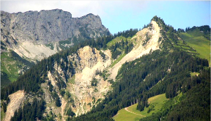
Monitoring a track warping testGIH was responsible for the metrological monitoring of a very unusual test conducted by Deutsche Bahn, a track warping test. A previously selected rail area was heated to a very high temperature, which initially caused the rail to deform and then warp. This track warping test took place in June 2017 in southern Lower Saxony.Led by: Ingo Neumann, Jens-André PaffenholzTeam:Year: 2017Duration: 05/2017 - 12/2017
![]()
![]() © GIH / U. Stenz
© GIH / U. Stenz


Projects | Expert-based data analysis and quality processes
-
Risk Minimization in Structural Safty MonitoringOne main goal of structural safety monitoring is minimizing the risk of un-expected collapses of artificial objects and geologic hazards. Behind these activities in the DFG founded project, it is the need of the society in mini-mizing the negative environmental impacts. An optimal configuration for measurement setups and all other decisions shall therefore review and ra-te the risks of an individual monitoring project. Nowadays, the methodolo-gy in many engineering disciplines and mathematically founded decisions are usually based on probabilities and significance levels but not on the risk (consequences or costs) itself.Led by: Ingo NeumannTeam:Year: 2010Funding: DFGDuration: 09/2011 - 08/2014
![]()
![]()
-
Simulation-based optimization of tachymetric network measurementsIn geodetic networks of large extent or with a large number of points, the tachymetric network measurement is usually associated with a high logistical effort. The individual measuring points must be visited again and again in order to align the reflectors to the current tachymeter position. The efficient planning of the measurement has the goal of causing the lowest possible costs or it aims at the shortest possible measuring duration.Team:Year: 2010Duration: 2010 - 2019
![]()
![]()
-
Efficiency optimization of geodetic measurement processesThe efficiency optimization of measurement and evaluation processes of engineering geodesy requires a detailed modeling of the individual sub-steps. This modeling is realized by means of Petri nets. Thus computer-aided simulations can be carried out. To minimize the cost or duration of the measurement processes Genetic algorithms are used as an optimization method.Led by: Hansjörg KuttererTeam:Year: 2009Funding: DFGDuration: 05/2009 - 06/2014
![]()
![]()


Projects | Land and Real Estate Management
-
Innovative approaches to services of general interest in rural areas - learning from the experiences of other European countries for Germany (InDaLE)In structurally weak and sparsely populated rural regions in particular, the consequences of demographic change and financially weak municipalities are jeopardising the existence of certain services of general interest. This is making it increasingly difficult to maintain services of general interest in the long term. Other European countries are in a similar situation, in some cases with a much lower population density. This is where the project comes in, in order to examine the extent to which there are established, innovative examples of projects for the provision of services of general interest in these countries, which can offer additional insights and solutions for Germany.Led by: Prof. Dr.-Ing. Winrich VoßTeam:Year: 2020Funding: Bundesministerium für Ernährung und LandwirtschaftDuration: 2020 - 2022


